Friday, 18 November 2016
Around Trottiscliffe: to be a pilgrim
Been wanting to do sections of the Pilgrims' Way in Kent ever since visiting churches like St Peter and St Paul Trottiscliffe (pronounced 'Trosley') on a first day's acquaintance with music@malling last year. This year's festival lunchtime attendance should have been followed by a walk, but the post-op stent was still giving such gyp so we limited it to a perambulation around West Malling. From the minute the stent came out, normal service was instantly resumed, so a proper half-day's hike was in order.
We started from the station in nondescript commuter town Borough Green, but you're quickly out and even negotiation of the two motorways whose roar is rarely completely out of earshot wasn't too much of a bind (unlike last year, when a tunnel was flooded and we had to walk half a mile along the motorway). This bank on the ascent to one bridge, for instance, was wild-meadow rich.
Wrotham is sandwiched between the two motorways, but you wouldn't know it once you're close. I'm not sure, since we approached it round the back
and never saw the drive, but I think this is Ford Place, described by John Newman in the Pevsner guide as 'an interesting fragment, one wing of a large Elizabethan or Jacobean mansion' with much later additions, I'm guessing.
Once past the horse paddocks, the North Downs are truly in view
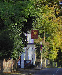
and then a tree-lined lane leads to Wrotham, where we had an excellent lunch in The Bull.
The ensemble of the main square, inclining upwards towards the Downs, is a good one, with handsome St George dominating. 14th century with a 15th century tower.
It was closed for a restoration project that will now be over, but we did at least walk under the west passage, the like of which I've only seen in Walpole St Peter
and past graves in the churchyard casting long Autumn afternoon shadows.
The cemetery's extended further up the hill
and then, negotiating the muddle of motorways, the Pilgrims' Way heads eastwards.
At first we walked a very pleasant undulating lane, taking detours off it when herds of cows weren't in prospect. This kind of prospect is familiar from Powell and Pressburger's A Canterbury Tale.
Into the woods, it felt even more like we were following the footsteps of Chaucer's pilgrims. Except for the odd disruption like two blokes on motor bikes using the path.
Then we were above Trottiscliffe, with good views down - albeit slightly marred by telegraph poles and wires - to the church.
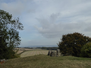
We had another treasure to pay homage to first. Perhaps the most atmospheric stretch of all was the one heading down to Coldrum Long Barrow, the neolithic site which was the discovery of the walk. Interestingly enough, the people heading up the hill were the only other walkers we encountered on the entire route.
Dating has suggested that the first burials took place between 3085 and 3055 BC, and the site was in use for another 200 years.
The sarsens of local sandstone were placed against all sides of the raised rectangular mound and are now fallen all around.
Most have fallen, but thanks to major preservation work in the 1920s, and the ongoing stewardship of the National Trust, this marvellous site seems safe.
You really feel like you're in the middle of nowhere here, with the motorway roar entirely absent (the M25 has bent away from the downs here). As you do in the ensemble of Norman church and 18th century houses nearby.
'It is a characteristic, if not a particularly picturesque, group,' sniffs Newman, but how many such groups can boast such a beautiful setting? As along the South Downs, there's something especially magical about religious buildings nestling beneath a hill with the sense of nothing beyond (even if a few roads do go over the Downs).
The interior, which we first had leisure to gape at during occupancy of a box pew for Sami Junnonen's flute recital last year, is essentially simple but made up of various odd components, not least the outsize organ.
Strangest occupant is the huge pulpit, designed in 1775 by Henry Keane for Westminster Abbey (or St Margaret's Westminster; accounts differ). It found a rather humbler home here in 1824.
Needless to say, the real oddity is the palm tree which supports the sounding board.
The 18th century altar rail, also not originally destined for this church, is very handsome too.
One original feature is the mix of medieval canopies and Trinity in a north window of the nave.
Last but not least, the local folk leave plentiful pots of jam for sale near the entrance, all labelled with a fine image of Bishop Gundulf/Gundulph from a more recent stained-glass window, so seminal a figure in West Malling, too.
We fairly hoofed it out of Trottiscliffe
passing a lone pheasant in a field
and back towards Borough Green, leaving the larger loop continuing the Pilgrims' Way eastwards for another excursion. This meant walking along a not too busy road with fine views to the right, albeit dark clouds gathering above,
and another, hard-to-make-out barrow
before heading under one motorway and finding a handsome house just to the south with Dutch gabling.
At the main road, J, anxious to get back to town, decided to pursue its hideously busy route while I headed southwards back into lovely woodland
and then up towards Borough Green just beyond Platt Woods.
We both caught the same train, incidentally. And I know from the ten minutes of the busy road I still had to walk how interminable much more of it must have seemed. Time has different values according to circumstance.
These new discoveries mean that we now know excellent walking routes reachable within an hour by trains going in all directions from the centre of London - north around Essex, west to the Chilterns and Ashridge, south to Lewes and the South Downs and eastwards here. Such riches.
Subscribe to:
Post Comments (Atom)


3 comments:
It's the gable with the blocked-up windows that was Ford Place.
I think I can see the building you thought was Ford Place on the Google satellite photo, but it doesn't seem to be listed, so perhaps it is _all_ later additions.
Thanks. Curiously the Ford Place you cite is a long way from where it appears on my map. Though I'd need to go back and check.
I was struck by it when I walked past it yesterday and Googled for information, which brought up your blog post. The gable end actually has a name plate on it now, though obviously it couldn't have had when you visited:
https://www.bing.com/maps?osid=9e74cde0-6fa2-4382-9362-324c7fddd765&cp=51.302781~0.345879&lvl=16.25&dir=86.675545&pi=1.170671&style=x&imgid=5ffae483-a007-4ea9-a5dd-f2b5e9d4d58b&v=2&sV=2&form=S00027
Post a Comment